Everything You Need To Know About Trekking In Kyrgyzstan During Your Kyrgyzstan Tours
Trekking in Kyrgyzstan is the highlight for many of those travelling to Central Asia. It is a popular activity among tourists looking for an offbeat travel experience. But the first-timers often struggle with planning the trekking tour and choosing Places To Visit In Kyrgyzstan.

To help you plan a Trekking Trip To Kyrgyzstan, we have created this comprehensive guide on the main trekking destinations in Kyrgyzstan and what you need to know before you go.
Majority of the trekking routes aren’t on the height where altitude sickness can cause a problem. Therefore, it is open to everyone from novice to experienced trekkers. However, peaks like Tengri Khan and Lenin Peak fall in moderate to the difficult range.
· Best Regions For Trekking In Kyrgyzstan
Kyrgyzstan positions itself as a trekking and hiking paradise in Central Asia. And why shouldn’t it? Majority of the country is mountainous and 80% of it is covered by Tian Shan mountain range. So needless to say there are numerous trekking trails. But not all of them are created equal and a selected few often outclass the others in terms of ease of trekking, scenery, and cost. Here are some of the regions where trekking is deemed best for Kyrgyzstan Tours:
Ø Jeti-Oguz Mountain Trekking
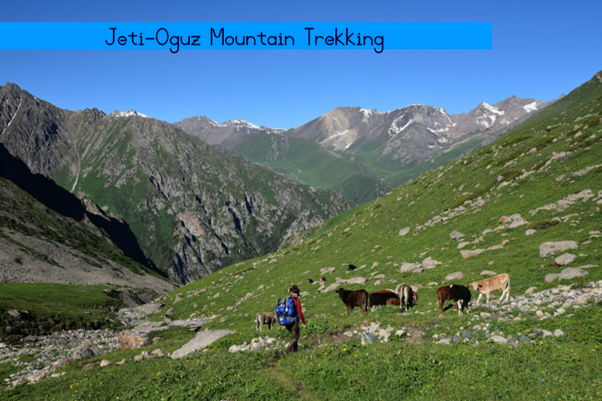
A 40 minute bus ride from Karakol will take you to Jeti-Oguz, which is an excellent Trekking Destination Of Kyrgyzstan. The verdant countryside gives way to the snow-capped mountains and the mountain is characterized by lush green environment almost in its entirety. The vibrant red-rock line from where you’ll see the rolling hills on one side and eroding canyon on the other side is the hiking stop point. From the top, you’ll see the majestic seven bulls directly in front. The Broken Heart which is another gorgeous rock formation located behind the bulls is another highlight of many Kyrgyzstan Tour Packages. The whole territory comes to a new life during spring season when the mountains get blanketed with wildflowers. A normal of 6 km trekking is recommended in Jeti-Oguz which takes about 2 hours.
Ø Ala Archa National Park

An alpine national park in the mountain ranges of Tian Shan, it covers an area of 200 sq km and altitude ranges from 1500 meters to 4895 meters. The park is also home to more than 50 mountain peaks and one can get to Peak Uchitel which is located at an altitude of 4527 meters through the trails of this park. As opposed to Jeti-Oguz, the trails in this park are rocky with heavy scree. But some fascinating scenery, tall alpine trees, and the rare while leopard are some of the reasons why you should trek in this park in your Kyrgyzstan Holiday Tour.
Ø Ala-Kul Lake Trek

Ala-Kul is a lovely lake sitting on an altitudinal level of and is part of the Ala-Kul nature reserve. The best way to reach the lake is by following a trekking trail which runs along the Karakol River. The hike to a bride on the eastern side of the river is relatively easy and from then onwards, it becomes quite strenuous and will lead you all the way to the lake. Camps are regularly organized near the lake shore.
Ø Khan-Tengri

The Khan-Tengri or Tengri Khan Mountain is a well-known mountain located in the China-Kyrgyzstan border on the eastern side of Issyk-Kul Lake, the tenth largest lake in the world situated in Kyrgyzstan. Some of the peaks are over 7000 meters with the highest one being at Peak Pobeda at 7439 meters.
Ø Lenin Peak

Lenin Peak is the second highest peak of both Kyrgyzstan and neighbouring Tajikistan. It rises to 7134 meters, but the climb is considered non-technical in nature and is among the easiest in the 7000-meters category. In Kyrgyzstan, it is located in the Osh region.
· Finding Trekking Maps In Kyrgyzstan
Ø Mobile Maps

Mobile Map services like those from Google, Bing, and Wikimapia are the best and instantaneous way to get the trekking routes. The data is reliable, up to date, and you can you mark important stops on the map. Moreover, they’re free. So there’s no logical reason as to why not to use them.
Ø Soviet Military Maps

While the Mobile maps do a wonderful job for the basic part, they lack the large scale topographical mapping feature for wilderness trekking. This can be accomplished by using the concerted effort made by the ex-USSR to map the entire world which includes the remote wilderness of Kyrgyzstan. These are more reliable and can be scaled down to 1:10,000
Ø USAID Trekking Maps

US AID stands for United States Agency for International Development and as the name suggests, it works toward development in international communities. In Kyrgyzstan particularly, it has Installed 125 Signs for tourists across the country and has created a comprehensive map for trekkers to use.
· Accommodations

While trekking in Kyrgyzstan, there are a number of resorts, huts, campsites, and homestays which will accommodate you during the night time. There are also few old Soviet camps in selected hiking campsites that were used during the Soviet period by the military. Staying in yurts is recommended not only during trekking but also during just plain exploring in your Kyrgyzstan Tour.
As said before, 80% of the country is covered by Tian Shan mountain range, hus, there are many more mountaineering destinations not included here. But besides trekking, there are other Kyrgyzstan destinations which are worth visiting at least once. For a complete list of Places To Visit In Kyrgyzstan or booking Kyrgyzstan Holiday Tours, contact Minzifa Travels today!


Comments
Post a Comment